|
| Grading Tools | ||
SmartDraft® Grading Tools' Dynamic Label Design Features Aid Drafting Grading to:
* Uses AutoCAD® Civil 3D® surface, profile, feature line, BricsCAD v20 Civil surface, and 3D polyline data. 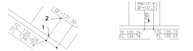 |
SITE MAP | PRIVACY POLICY | LICENSE AGREEMENT | TERMS AND CONDITIONS
AutoCAD is a registered trademark of Autodesk, Inc. SmartDraft is a registered trademark of SmartDraft, Inc.
Microsoft is a registered trademark of Microsoft Corporation. All other brand names, product names, or trademarks belong to their respective holders.